EXCAVATIONS AT COSA (1991-1997), PART 2: THE STRATIGRAPHY
Part 2: The Stratigraphy
> Trenches in the Area of the Forum, and IX D North
> Forum II and III
|
The Byzantine period Over the construction deposit next to the temple was found a wall, 11, which had previously been observed by Richardson at the east corner of the temple. Although the construction trench for this wall had presumably been cut from a higher level, the stratigraphy related to it had been almost entirely cut away by the medieval cemetery, so that it appeared simply to sit on the layer of spalls. It was constructed of stone and white mortar, and measured 47 cm. across. Although preserved to a height of no more than 45 cm., it must have been considerably higher, as a well-preserved collapse (9) ran from the wall for over two meters and beyond under the southwest section of the trench. Thus it stood, at a minimum, to shoulder height. It could be followed from a point some four meters to the northeast of temple B, running parallel to it. It then swung around the east corner of the temple, and ran south, for 10 meters, turning southeast towards the eastern corner of the forum. Cut by a later ditch, its traces were lost in the southeast end of the trench, but it may have run towards the southeast gate. The irregular line of this wall suggests that it formed the edge of a road, running from a point to the rear of the Curia (part I, p. 78ff) towards the southeast gate and the port. Traces of compaction over the construction deposit and 21 may be related to this road, but we cannot be certain. Although no dating evidence for it was present in this trench, the wall's stratigraphic position puts it after the construction of temple B and before the medieval cemetery, which cuts both the wall and its collapse. It seems reasonable to associate it with the sixth century ramp that runs up through the Curia towards the forum. The Medieval period The cemetery (12) has already been discussed (part I, p. 99ff.). Over 70cm. deep within the excavated area of the trench, it was probably even deeper next to temple B, where Richardson recovered some 80 bodies. The continuous cutting of tombs destroyed any intervening stratigraphy in this area. Towards the southeast end of the trench, however, where the graves were sparser and individual cuts could be recorded, they cut into a fairly clean earth just above bedrock. The tombs in this area were covered by a thin layer of hillwash, 14, containing only residual material, which suggests that this area of the cemetery was abandoned before the next occupation.
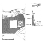
The hillwash, and the south-easternmost tomb (Bu 60), were cut by an irregular shallow ditch, running across the trench from northeast to southwest (38: pl. 45 and fig. 60). This was on average 3m. wide, although it narrowed to 2m. at its northeast end. U-shaped in profile, it was never deeper than 1.20m. The earth from its cut was piled up on its southeast side, against the Roman wall 16, to form a low bank (24). On this was constructed 18, a small square foundation, 25 x 2.8m., which incorporated 16 and its return, 63 (see pl. 25). The foundation was preserved for one course only, neatly faced, with no mortar and an inner fill of rubble and earth, the rubble possibly deriving from 16. This construction is probably to be related to two walls that were excavated in Forum III (Forum III 5 and 3: pl. 46). Preserved for one course only, these lay at right angles to each other and parallel to the square foundation. On the southwest side of wall 5 was a compact surface of beaten earth and small stones, 12.
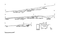
A final element in this complex is a second ditch, 50 (fig. 61 and pl. 47), in the eastern corner of the excavation. This was considerably larger than 38, measuring at least 6m. across, with a U-shaped profile a minimum of 3m. deep. Again, the earth from this ditch appears to have been thrown towards its uphill, or eastern side, emphasizing the natural slope. The ditch, and the bank to its west, (65) were finished with a layer of fine clay (56), traces of which were also present in the outer ditch (41). A single posthole was found cutting this layer, (52) with the suggestion of a stone packing. It may suggest a palisade, but in the absence of a second posthole the question must remain open. The ditch seems to reappear on the other side of trench Forum III, wall 5: the cut is visible on pl. 46. On plan, these five elements Ò the two ditches, the square foundation, and the two banks Ò seem to comprise a complex fortification, although the baulk between the two trenches leaves certain aspects of it in doubt. The outer ditch is missing in Forum III, and thus must have come to an end between the two trenches: indeed, a large lump of bedrock in the middle to the trench seems to signify that it is running out. In Forum III, the line of its outer edge is taken by III 6, a wall which must have had the same, rather minimal, defensive function. The inner ditch, 50, is also interrupted between the two trenches, although it continues on the other side of the wall in Forum III, 5. This wall must thus be interpreted as delimiting a narrow causeway, whose surface would be constituted by 12. We do not know whether a wall parallel to 5 lies under the baulk, but this seems likely. It is thus probable that there is an entrance through the fortification at this point, and that the square foundation 18 can be interpreted as a guard post. The absence of mortar and the very small amount of rubble found in its destruction layer 44 suggests that it was not stone-built to a higher level, so a wooden construction seems the only possibility.
We do not know how long these defenses were active. In the outer ditch was found what may have been a deliberate burial, 57, although no cut was observed. The skeleton (the body was largely under the southwest baulk) lay along the line of the ditch, and the absence of a cut may suggest that it was simply left where it fell. It was covered by one of a series of fills, (40, 39, 29=22) which are probably contemporary with those of the inner ditch (51, Forum III 7). These fills were relatively clean, of black, powdery earth, with some pottery and fire-cracked rocks. The lowest, 40, contained much red earth, and probably slipped in naturally from the sides of the ditch. At some point after the ditches had almost entirely silted up they were re-cut ( 37 recuts 38, 48 and Forum III 10 re-cut 50), although the profiles of the new ditches were even shallower than before. The fills of the re-cut ditches were much richer in domestic debris (33, 47, 45 and Forum III 6, 2) than the earlier fills, which may suggest a period of more intense occupation within the defenses of the settlement. The final abandonment of the defenses is marked by the construction of a small hut (fig. 62) that covers the line of the outer ditch. This consisted of a rubble make-up, 13, punctuated by six postholes, forming a square with four postholes along its northwest side. This side was also emphasized by a shallow cut, 23, which may have encouraged drainage downslope. The structure, which appears to have been open towards the southeast, faced the remains of the wall 16. A rough beaten-earth surface, 20, covered the area, both inside 13 and just outside it. The structure as a whole is probably to be interpreted as a rough shelter, whose roof would have been carried on a beam supported by two firmly set posts in front of the building. Pottery contained in the makeup included 'testi', but no glazed pottery, with the single exception of a sherd from a North African filter jar which came from the interface between 30 and 4 in the area of the hut7. A fairly clean layer some 30cm. thick, 4, marks the abandonment of the area of the trench. This probably consisted of hillwash, accumulating over a considerable period of time. Over this lay modern plowsoil, 1, cut by a small pit (2, 3) and, in the southern corner of the excavation, the excavation trench of the carcer (27, 28). [ back 1 2 ]
7. This sherd was somehow lost: it was identified on site and its presence recorded in the notebook.
|
Part 2: The Stratigraphy
> Trenches in the Area of the Forum, and IX D North
> Forum II and III
© 2002 Adam Rabinowitz and Elizabeth Fentress
Design © 2002 Adam Rabinowitz and Nicholas Rabinowitz
All rights reserved.