EXCAVATIONS AT COSA (1991-1997), PART 2: THE STRATIGRAPHY
Part 2: The Stratigraphy
> The Eastern Height, EH I-VIII and X C
> EH VI
|
Medieval structures
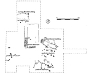
Again, we are not helped by the dearth of clear stratigraphy on the hilltop. To the northeast of the ruins of the temple the most significant later feature is a rectangular cut in bedrock, 50-70cm. deep, and running east-west (14). This lay partially over the line of the road, and measured 2.5 x 7.5m. At the bottom of the cut was a layer of light brown clay, 17, compacted on the surface and 20-50cm. thick, which fills hollows in bedrock. The eastern end of the feature is steeply cut, with apparent ledges on either side measuring 15cm. wide. In the western half of the cut, where the natural bedrock is lower, the sides are packed with small stones in clay. Only at the eastern end are these stones regular enough to suggest a wall foundation, but it is probable that all the packing served the same function. This is interpreted as a sunken-floored hut, Building 1 (pl. 40). The cut bedrock at the bottom of the structure is extremely irregular, with one massive circular depression in the center. The bedrock could not have provided a usable floor surface, and, unless the irregular layer 17 can be interpreted as a floor, we must assume that the whole was planked over with timber, supported on the ledges and packed foundations. Outside the building and at its NE, SE and SW corners, were a number of postholes whose relationship to the structure is not entirely clear, but which may have supported or reinforced a timber roof (6, 7, 23, 28, 29, 33, and 34). These postholes were distinguished from natural hollows in the bedrock by the presence of apparently anthropogenic fills within them, as well as their more regular form. One, 33, seems to have been encased in the layer of packing rather than cut into the stone outside. The destruction layer, 12, contained a number of large stones, which suggests that the building was walled, at least in part, with stones rather than with wood or wattle. The circular hole in the center could be interpreted as a posthole for a large vertical timber, which may have supported rafters leaning in from the external walls. A second structure of the same type, Building 2, was found to the west of the temple, running parallel to its rear wall. This was a subrectangular structure, 3.7m. wide, defined by irregular cuts in bedrock (see pl. 24). The hut was not fully excavated, as it ran under the section, but its minimum length was 6m. The cut is roughly 40cm. deep, and is ringed by postholes, suggesting timber walling. It is filled by large stones with earth on top of them: again, it is something of a quandary whether the flooring was of wood, or whether the rough compaction above, 157, can be interpreted as a beaten earth surface. A semi-circular group of stones, 162, might mark the position of a hearth at the level of 157. Access to the structure was apparently from the south, along a path, 213. Timber Buildings The destruction of these two sunken-floored buildings seems to have been very thorough, with the heavy stones that made up their walls pushed into the hollows, and the whole filled with earth. Over the western hut a layer of relatively clean earth, 167, accumulated, covered by colluvial material, 174 and 151. Over the eastern building a compacted layer of earth, 13, must represent a further occupation of the hilltop. This surface may be associated with a timber structure, Building 3, whose presence is suggested by a double line of postholes to the southeast (pl. 41). These are fairly irregular, but seem just large enough to have supported building timbers. The orientation of the structure is different from that of the sunken-floored building, and almost directly adjacent to it; indeed posthole 10 almost touches 28, which was tentatively interpreted as a slot for a roof-timber in the earlier building. Thus although the possibility that the two were contemporary cannot be ruled out, it seems more probable that the posthole structure was constructed after the first building had been destroyed. It would have measured 6 x 2m., and was lacking anything that might have been interpreted as contemporary surfaces, with the possible exception of the trample that overlaid the destruction of the sunken-floored building. A second rectangular timber building, Building 4, lies 4.5 meters southeast of the first. Its sides are marked by a double row of very irregular postholes. A square depression 30cm. deep is cut into the bedrock at its southwestern end, clearly marked by four corner postholes (pl. 42). How this is to be interpreted is not entirely clear: perhaps there was a functional distinction between the two ends of the building, which measured 7.5 x 3m. overall. To the west of this building a thin surface, 171, may represent its occupation. A fifth building on top of the temple is very different from the others, being regularly constructed of stone walls. Two of these were preserved over the temple, the first, 235, running along the line of the fa¡ade of the temple, the second, 236, across the middle. A posthole cutting the podium fill, 132, may represent a support for the roof. The side walls must have used the temple walls as foundations, but nothing is preserved of these. Outside the structure, along the line of the Roman road, a beaten earth surface, 172, seems to be associated with the life of the building. The southwestern half of the trench yielded no certain evidence for occupation, although five clear postholes might suggest further timber buildings. It is probable that all of these structures, with the possible exception of Building 5, were abandoned at the time of the construction of the castle, a moment which seems to coincide with the robbing of all surviving walls (111). In the area of the Roman road a thin, compacted layer, 4, is almost impossible to date. Lying over this, 2 presented a roughly cobbled surface, well compacted. The presence of archaic maiolica in the fill suggests that it is contemporary with the second phase of the castle. Over the whole of the area a thin layer of brown-brown silt and sand, 101, represents modern debris and humus, possibly dating from the use of the area for a radio tower during the Second World War. [ back 1 2 3 ] |
Part 2: The Stratigraphy
> The Eastern Height, EH I-VIII and X C
> EH VI
© 2002 Adam Rabinowitz and Elizabeth Fentress
Design © 2002 Adam Rabinowitz and Nicholas Rabinowitz
All rights reserved.